Understanding human uses of the ocean is essential to successful marine planning, but spatial information on ocean uses is often scarce and difficult to capture consistently over large areas. Participatory geographic information system (PGIS) methods provide interactive ways to capture local knowledge and ocean-use patterns through specialized GIS mapping tools. A new resource, Guidebook to Participatory Mapping of Ocean Uses and Appendices, explains NOAA’s methods for developing and implementing a participatory mapping project. Visit How to Map Ocean Uses with Participatory GIS for an abbreviated version of the guidebook.
The following projects applied the NOAA PGIS methods across a wide range of geographies and scales with various types of partnerships and budgetary constraints. All shared a similar goal of filling critical data gaps using a stakeholder, expert-driven process to inform planning.
The Projects
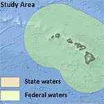
The Pacific Regional Ocean Uses Atlas (2015)
This atlas is designed to document a full range of human activities and sectors in the ocean to support offshore renewable energy planning in the Bureau of Ocean Energy Management’s Pacific region.Background | Report
American Samoa Coastal Use Mapping Project (2012)
The American Samoa project will inform planning and management activities in the greater Pago Pago Harbor region known as Fagaloa, an American Samoa Coral Reef Strategy priority site.Background
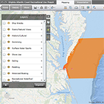
Virginia’s Atlantic Coast Recreational Use Mapping Project (2012)
This project supports Virginia coastal zone management planning efforts and fills regional data gaps for the Mid Atlantic Regional Council on the Ocean (MARCO).Background | Other Resources
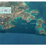
St. Thomas East End Reserve Coastal Use Mapping Project (2012)
Coastal managers will use data from this project for marine protected area planning and plan review in the U.S. Virgin Islands’ St. Thomas East End Reserve.Background (with links to download data)
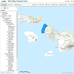
West Maui Coastal Use Mapping Project (2011)
This project informs coral reef conservation and planning strategies for the west coast of Maui.Background | Access Web Services
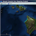
Hawaii Coastal Use Mapping Project (2010)
This project supports the development of coral reef conservation and planning strategies for the northwest coast of the Island of Hawaii.Background (with links to download data) | View Data | Access Web Services
New Hampshire and Southern Maine Ocean Uses Atlas (2010)
The impetus for this atlas was to inform a Spill of National Significance Drill in Portland, Maine.Background (with links to download data) | Access Web Services | Other Resources
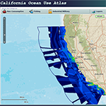
California Ocean Uses Atlas (2008-2009)
This project was designed to support the California Marine Life Protection Act Initiative’s marine protected area designation process.Background (with links to download data) | View Data | Access Web Services
Learn More
Contact NOAA’s Mimi D’Iorio for more details about these projects and how you can get started in your area.
Resources
Identification of Outer Continental Shelf Renewable Energy Space-Use Conflicts and Analysis of Potential Mitigation Measures – Provides insight to identify and avoid ocean use conflicts.
Introduction to Planning and Facilitating Effective Meetings – Explains the role of a facilitator and describes how to plan and execute meetings that deliver results.
Introduction to Stakeholder Participation – Discusses some of the most important considerations and offers a guide to the most common techniques of stakeholder participation.
Mapping Human Uses of the Ocean – Outlines the PGIS process to gather ocean use data through workshops that engage local and regional ocean experts.
Newly Updated: A Common Language of Ocean Uses – Provides practical, intuitive, and regionally flexible definitions of a wide range of typical human uses.
Ocean Uses in the Monterey Bay National Marine Sanctuary – Provides a case study using the California Ocean Uses Atlas to shows how human use data can inform place-based management.
A Review and Summary of Human Use Mapping in the Marine and Coastal Zone – Describes a project that researched and synthesized methods and approaches to map human uses.
Stakeholder Engagement Strategies for Participatory Mapping – Provides simple strategies for facilitators leading a participatory mapping process.